
A Whole-Waterway Plan and What Starts It
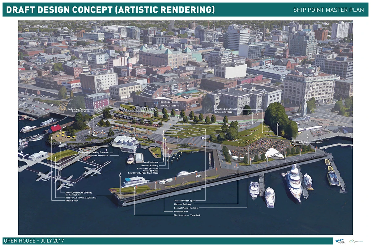
From the outer wharf up to the head of the inlet, our city holds a long and unusual waterway that could become a celebrated single ecosystem and the signature landmark of the city and the wider region.
It would take close work with the neighbouring shore municipalities, with the regional district, and with the industrial and residential owners of the upland banks. A “whole waterway” vision would gather the ideas and plans each of them holds into one collaborative effort, producing a unified ecosystem that shows the relationships between the people and the animals living on the lands and waters along its length. As it has for other far-sighted projects, our city can convene and chair that table.
Our city already holds the obvious starting point for a regional effort of that kind – the Inner Pier Master Plan, first drawn out of the Harbour Vitality Principles in 2014, then the Inner Pier Concept Options and Master Plan Assessment Phase Summary papers of May 2017, with public engagement and reporting through the summer and autumn of that year. Staff presented the master plan to council in early summer 2018, where it was welcomed but only “received for information”, pending a later resolution directing staff to come back with costings and an implementation strategy. That resolution never came, so the plan has sat on a shelf ever since.
The plan sets out a comprehensive vision resting on three ideas: a green terrace, with expanded green space, flexible open ground, wide views and an extension of the shore-side street; a connection hub, offering multi-modal transport links, an unbroken waterfront route, access to and from the water, vehicle access and parking; and a commitment to a working harbour, with permanent structures, a varied shoreline, improvements to the harbour economy and better marina services.
A renewed inner pier would give the district a distinctive venue for events, an inviting place to visit any day of the week, and easy, accessible movement through it, with materials that balance character against innovation in a sustainable, resilient design – a destination worthy of the finest waterfront land we have.
The inner pier plan appears in each of the last two approved civic strategic plans. The current one carries the note: “Review the inner pier improvement plan and consider funding options”, pencilled in for 2023 under Strategic Objective 8, Strong Liveable Neighbourhoods. The previous council’s plan referred, in its 2019 objectives, to “Increased waterfront park space at the inner pier resulting in community wellness and economic vitality”. Each time it has been placed a year out, so staff have never formally been asked to report back on what proceeding would involve, and council has never been in a position to move it along.
Beyond the striking addition it would make to the waterfront and inner harbour, the community benefits of building the plan are considerable, beginning with something in the order of 70 to 100 construction jobs across the build phases, and going on to the longer-run value of the space itself and the tourism and economic activity around it – itself a source of work.
The longer-term list runs on. Liveability, and a far larger urban park for a downtown population that keeps growing. Tourism drawn by a striking waterfront park. Connectivity, linking the shore-side street to the water and closing the gap in the waterfront walkway. Ecological gains from replacing parking lot surface with terraced planting that softens the urban heat island. A better platform for performance and festival programming, and a longer season for events. More room for local artists and cultural work in a public setting. Micro-retail – food and drink – to bring the waterfront to life and give residents and visitors somewhere to go. And a fit with the city’s capital planning, given the shoreline repair and restoration due in the coming years. Among others!
Timing matters. The plan foresaw four phases, spreading the funding out and keeping the site in operation through construction (float plane access, the summer festivals and events). Phases 1 and 2 might each take up to 18 months, and could plausibly overlap. Phases 3 and 4 are bigger and probably run to at least 24 months apiece. That means phases one and two can be finished, and phase three begun, inside the next term.
Costs have plainly risen since the plan was first drawn five years ago. Rough costing in 2018 put the full four-phase capital cost somewhere between $60 and $75 million. A current estimate is one of the first things that would need doing.
A good share of that – perhaps a quarter or more – is shoreline restoration and stabilisation the city will have to face before long in any case, and could reasonably sit in a separate budget. Because the shoreline work belongs to ordinary infrastructure spending, it could be a practical way to bring phases 1 and 2 forward, since those phases sit on the shoreline stretches, and the economies of scale would be real. Even setting the shoreline work aside, phases 1 and 2 are smaller in both cost and scope and are the logical first pieces, enough to prove the value of the whole and to show progress.
Experience suggests parts of the project would qualify for provincial or federal support. The plan advances several strategic themes at once – liveability, urban parks, cutting the heat island effect, cultural space, shoreline rehabilitation – and every one of those is named as a priority by senior governments. Those governments are also readier to match and fund work of this kind where private donors have contributed, since that reads as evidence of community backing – and the board believes the plan would attract exactly that backing once the city commits to building it.
The inner pier is only a small piece of a world-class vision for the whole waterway from the outer wharf to the head of the inlet. It is one of several pieces – among them the outer wharf master plan, worked out with the harbour authority, and the extension of the harbour pathway including its pedestrian bridges – over which the city can act on its own authority, while seeking a shared planning process with the neighbouring shore municipalities, the regional district, the industrial and residential upland owners and, where needed, senior governments, toward a whole-waterway vision.
The Inner Pier Master Plan has been in the works, and on the shelf, for more than eight years. It is the catalyst for re-imagining a landmark natural ecosystem that begins in the city and shapes the region. It is time to take the plan down, bring it up to date and get to work.